A lot of people have asked me how I get my photos. No, not the ones you see on my Instagram—the ones I use for work. I’m a photogrammetrist, which means that I make maps and 3D models using imagery taken by planes or satellites. But lately, drones are stealing all the thunder (and replacing some of my work). And while drones can be used in countless ways within photogrammetry, many people don’t know what photogrammetry even is. So if you’ve ever wondered what goes into creating a map of your house or a 3D model of your street for fun or for business reasons, read on; we’re about to demystify the exciting world of drone photogrammetry!
Drone photogrammetry is a surveying technique that uses drones to capture images and process those images using specialized software to create maps and 3D models for surveying, construction, mining, insurance and other industries.
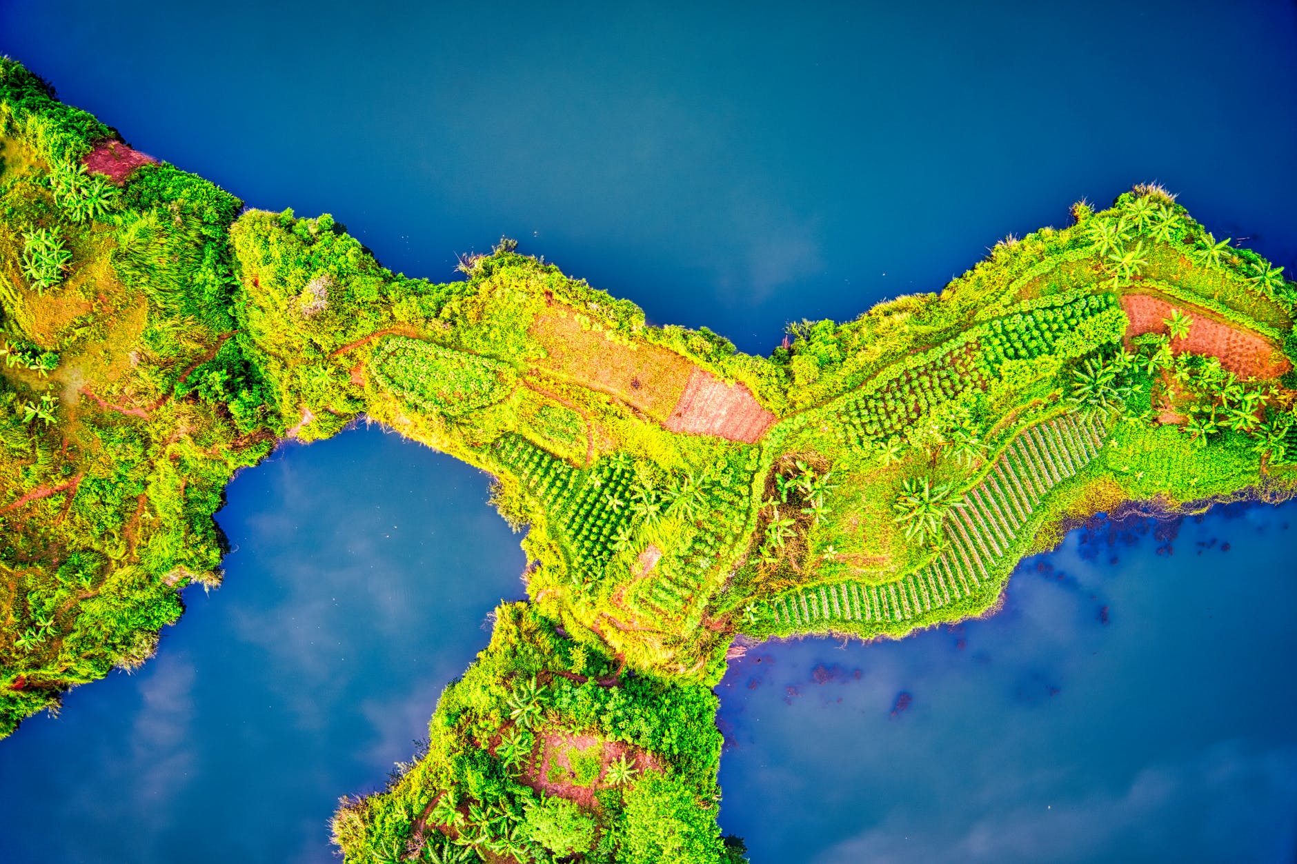
So, how does drone photogrammetry work? It all begins with taking a series of photos from the same point in space. These can be captured with a camera or by using a laser scanner. The drone then moves to another location and repeats the process until it has covered an area. At this point, the images can be stitched together into one large image called an orthomosaic map – this is what you see when you Google Maps your street!
The next step is to process these images through specialized software that analyzes them for patterns like textures and objects such as buildings, roads or vehicles. This data is then used to create 3D models of terrain features or individual objects within those terrains which are extremely accurate down to millimetre levels without needing any ground control points (GCPs) like Google Maps does!
Drones also can be used in many ways beyond photogrammetry. They’re often used for search and rescue, firefighting, mining and farming operations, law enforcement, movie-making, military operations and more.
Drones are also used for many other purposes besides photogrammetry. Drones can be used for search and rescue, firefighting, mining and farming operations, law enforcement, movie-making and more.
Drones are getting increasingly popular in the world of work. There are many industries that use drones as part of their business model or daily operations — including agriculture (farmers use them to monitor crops), construction (they help determine where new buildings should go), entertainment (the film industry uses them to take aerial shots) and search & rescue (they’re used to find missing people).
How does drone photogrammetry work?
First, a drone takes aerial photos of the site. Next, the images are uploaded to software that aligns them and removes distortions. Finally, software creates a 3D model based on the images that can be used in many industries.
The process typically begins with an initial inspection of the area by an engineer or surveyor who creates an initial map based on their visual observations. This usually involves taking notes and measurements as well as sketching out what they see so far on paper or using specialized software such as SketchUp or AutoCAD 360 Pro
This data is then used by photogrammetry engineers to create digital maps of large areas using drone technology
Photogrammetry software processes the photos taken by drones to create maps and 3D models.
Photogrammetry is the science of making measurements from photographs. When you combine a bunch of photos, you can use photogrammetry software to create maps and 3D models for surveying, construction, mining, insurance and other industries.
The software processes the photos taken by drones (called “UAVs” or unmanned aerial vehicles) to create maps and 3D models that are more accurate than what humans can do with their eyes—and it’s much faster!
There are several steps involved in drone photogrammetry:
(1) Drone Image Acquisition
First, your drone will take a photo of the area you’re interested in and then send it to the software for processing.
(2) Drone Image Processing
Once the images are sent from your smartphone or tablet to the software program, it will automatically process them so that they’re ready for analysis. This is what differs from traditional photogrammetry, where manual image processing is required before any data can be analyzed.
(3) Data Analysis / Visualization of Results
After all of this is done, there’s one final step—but it’s also one of the most important parts: analysis! This process involves looking at all of the data collected by both drones and satellites (which we’ll cover later on), combining it into 3D models with different levels of accuracy based on how much effort went into collecting each individual piece. This can be done using several different types of software programs such as Pix4Dmapper or Agisoft Photoscan
Steps in drone photogrammetry
Drone photogrammetry is a process that uses drones to take high-resolution aerial photographs and videos of an area. These images are then used to create high-quality 3D models, which can be used for many applications in the field of architecture, engineering, construction (AEC), archaeology, urbanism and other fields.
Using unmanned aerial vehicles (UAVs) for this purpose has several advantages compared to using traditional methods such as terrestrial or satellite cameras:
- The drone can fly at lower altitudes than manned aircrafts so it can make higher resolution images. This is especially true when capturing over water surfaces like lakes or rivers where low-flying helicopters are often prohibited due to safety concerns
1. Drone image acquisition
The first step to drone photogrammetry involves acquiring images. These images should be taken from the same angle and height. This helps the software determine how far away an object is by comparing the relative distances between each picture taken, as well as their orientation.
As you can imagine, there’s a lot that goes into making sure your photos are consistent enough for this process to work. You’ll want to make sure your drone has been calibrated correctly so that it can fly straight and level at a set altitude, otherwise you’ll end up with some pretty worthless results!
2. Drone image processing
Drone photogrammetry is the process of using drone images to create maps and 3D models. The software that processes these photos is called “photogrammetry,” and it’s an industry-standard tool that allows mapping firms to quickly build high-quality maps.
When you think about how many different types of data can be gathered with a drone, you may wonder: How do I know what kind of map or 3D model I need? There are three primary types of drone photogrammetry projects:
- Topographic surveys map elevations on the Earth’s surface in order to measure changes in elevation over time (i.e., flood plains).
- Geological surveys look at mineral deposits under the Earth’s surface by measuring them from above.
- Civil engineering surveys examine existing structures such as buildings, bridges and roads for damage assessment purposes.
3. Data analysis / visualization of the results
Data analysis is an important step for creating maps and 3D models. When you have a lot of data, you need to know how accurate your results are. You can use the data analysis to determine whether or not your drone has captured enough information about the location of a building or objects in order to create a 3D model or map. Data visualization is also important because it allows users to see their results in a format that can be easily understood by non-experts. For example, if we want someone who doesn’t know what photogrammetry is (like my mom!) to understand how our project turned out, we could send them an image showing all of our buildings with different colors assigned depending on which team they belong too!
Drone photogrammetry is a process for creating maps and 3D models using drones and specialized software to analyze the photos taken by drones.
Drone photogrammetry is a process for creating maps and 3D models using drones and specialized software to analyze the photos taken by drones. Drones are unmanned aerial vehicles that can fly autonomously or be piloted remotely from the ground.
The process of drone photogrammetry involves flying a drone into the air, taking photos of an area, then processing those photos through specialized software to create maps and 3D models. Photogrammetry is used in many industries including surveying, mapping construction sites, architecture design, archaeology and agriculture.
Conclusion
Did we convince you that drone photogrammetry is not a big deal? It’s actually a pretty simple process. If you have the right software, it’s as easy as getting your hands on some pictures and then analyzing them with your computer. However, drone photogrammetry isn’t just about making maps or 3D models—you can also use it for surveying, construction, mining, insurance and other industries!